Construction and Confusion on the Pan Am Path


Fair-weather pedal pushers of the city rejoice: Cycling season is finally upon us.
I’m relatively new to Toronto; having been here about a year and like many cyclists, now that the weather is warm again I’ve been trying to find a place for an extended ride.
Earlier this spring I discovered the Pan Am Path, the city’s arts-focused legacy of the 2015 Pan Am Games. Excellent, I thought. Let’s give that a try.
So last week (before the deluge of Rainmageddon 2017) I set out to ride the full 85-kilometre length of the Path for myself, imagining the cheeky ‘So-you-don’t-have-to’ headlines that might follow.
What I found is that you likely will want to, if you don’t mind dodging construction closures, confusing signage and ultimately getting lost somewhere in Scarborough for a while.
The Pan Am Path began as a way to create a lasting legacy of the 2015 Pan Am Games. A group of civic activists pitched the idea of showing off the city’s ravines and the neighbourhoods they wind through, stitching together the existing pieces of multi-use pathway into a cohesive whole.
The City of Toronto got on board, promising $1.9 million towards the project to “act as a living legacy” of the 2015 Pan Am Games, according to the Friends of the Pan Am Path website.
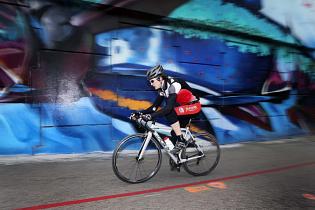
Underpasses along the route are decorated by graffiti art and other installations by renowned Toronto artists. The summer of the Games, the Pan Am Path played host to a bicycle-bourn mobile concert series, which was repeated for the anniversary last September.
Devon Ostrom is one of the project’s curators. He said the original idea for the Path was to address some of the very headaches I ran into last week.
“It first started back in 2012 as a response to having these beautiful amazing experiences in the city’s ravines and then being dumped out onto a highway,” he said.

Having an entire end-to-end pathway that doesn’t require sleuthing around Scarborough’s residential streets is still very much the goal, Ostrom said, but it’s a work in progress.
Its original incarnation called for the path’s construction to be 95 per cent complete by 2017 but after riding the whole thing it seems that the finish line will prove elusive.
Last Wednesday I arrived at the Pan Am Path’s western terminus near the Claireville Reservoir to find that there isn’t any signage denoting the start of the legacy pathway. There is, however, a fair amount of construction going on nearby – something that would become a bit of a theme for my four-hour, 93-kilometre journey.
From the reservoir dam the path sweeps down into the Humber Arboretum, green and lush with buttery smooth asphalt. The section through the Arboretum is beautiful, but with a number of forks in the trail and not much clear Pan Am Path signage, it’s a good thing I had a smart phone in my pocket.
From the Arboretum the path follows the river almost continuously until the waterfront. I say “almost” because significant portions of it are closed for construction.
The bridge where Highway 401 crosses the Humber is under construction, and the path runs beneath it. When I rode through, there were city signs saying the route is closed, pointing to a detour along Wilson Avenue.
The Ministry of Transportation later told me those signs are left over from a closure a year ago, and will be removed soon.

But farther along at Cruickshank Park I’m confronted by a blue steel fence and a snarling excavator hulking over the pathway like a dragon.
As the Toronto and Region Conservation Authority’s Moranne McDonnell explained to me, they are doing shoreline remediation work necessary to repair an area behind an apartment building on Scarlett Road that got washed out in a summer flood in July 2013.
“Basically we’re using big boulders and native plant material to rebuild the slope face,” she said.
McDonnell said that workers should be finished rebuilding the slope by the end of May, but parts of the trail could remain closed into June as crews replace paving and do other clean-up work.
Unsure how to get out of the ravine, I got off my bike and tiptoed towards the fence, hoping to slip around it. Eventually the excavator’s operator saw me, lifted his bucket back inside the fence and waved me forward.
A few more dekes around back-hoes and dump trucks, and I was back on the path headed south again. There was more fencing and heavy machinery as I pedaled towards King’s Mill Park. The trail itself becomes gravel for a while, but it’s still open.
After King’s Mill Park, I was spit out into the bike lane on Stephen Drive. The map says to pick up the pathway at South Humber Park, but there’s nothing in the way of signage to point the way. Again, it was my smart phone that rescued me.

After ducking under the Gardiner (and avoiding more construction), the path connects with the Martin Goodman Trail at Sheldon Lookout and along the waterfront towards downtown.
I’ve ridden this section many times and, as anyone who owns a pair of bib shorts can tell you, sometimes it’s gloriously empty and smooth. Other times, you’re constantly weaving and braking to avoid being clothes-lined by the leash on someone’s dog and all the other walkers who don’t seem to realize that there’s a pedestrian-only pathway mere metres away.
Such is life in a big city, I suppose.
Go west and you arrive in Mimico where the trail keeps mysteriously ending, leaving users on largely unmarked residential streets.
Headed east, you eventually reach the utter confusion of the Cherry Street intersection with Lake Shore Boulevard. Every time I reach this spot I’m never sure exactly what to do – cross at the three different sets of lights and head up towards the GO Train tracks (past another construction closure) or head south towards Cherry Beach.
Again, there’s no signage to help you.
After two hours in the saddle with nothing to eat but an energy bar and too much coffee I chose wrong, headed south and off the Pan Am Path proper. I’d assumed – mistakenly – that a city-wide trail meant in part to showcase Toronto’s green spaces would include the Leslie Street Spit.

After my accidental detour, I rejoined the Path at the mouth of the Don River. Riding up the Lower Don Trail you can get as far as the pedestrian overpass at Riverdale Park where you have to hike-a-bike up the stairs and over to Broadview Avenue to avoid more construction (which I wrote about earlier this month).
Out of respect for the city’s cycle-commuters – a much heartier bunch than I – I won’t belabour the problems with riding sandwiched into a few feet between streetcar tracks and a line of parked cars, waiting for an inattentive driver to open a door. All I will say is the detour up Broadview Ave. to Pottery Road is the city’s recommended route around the Lower Don closures and it doesn’t include a bike lane.
From Pottery Road it’s back down into the Don Valley for a short while until you reach Taylor Creek Park. Or do you continue on to Stan Wadlow Park? Despite 20 minutes of poking around I couldn’t find the trail. I cheated and zipped up Pharmacy Avenue, hoping to rejoin the Path at the Ashtonbee Reservoir and was met by more construction.
This is where I really got lost. The only map of the Pan Am Path I could find online doesn’t include granular, street-by-street detail. This is a problem when, like in Scarborough, the intended route jumps around on various residential streets
Even using the navigation apps on my phone I couldn’t figure out exactly where to go so I cheated once more and made straight for Thompson Memorial Park where I picked up the Path east along the hydro right-of-way.
Eventually, after a quick descent down Orton Park Road, the Path sweeps down through the serene Highland Creek ravine before arriving at the final, glorious 3.5-kilometre stretch along the lakeshore to Rouge Beach Park.

On the whole, it wasn’t a terrible four hours of pedaling. The art along the route is worth seeing if you can find your way to it, and at some points in the ravines you can almost forget you’re surrounded by six million people.
Last week Toronto passed its Ten Year Cycling Network plan, which will see $16 million invested per year towards 525 kilometres of cycling infrastructure. The vast majority of those kilometres will be on-street infrastructure aimed at improving cycling safety and getting cars off the road. Only 40 of those planned kilometres will go towards multi-use trails like the Pan Am Path.
The organization is planning to launch its summer programming schedule June 15, and it’ll include a whack of group walks, rides and tours. There will also be 15 new large-scale murals commissioned to add to the artwork already in place.
The next section of the Pan Am Path to see construction will extend the route from the upper reaches of the Lower Don Trail to the hydro right-of-way. That work will commence in 2018, along with three new pedestrian bridges in the Highland Creek and Morningside Park areas, according to the city.
Even so, the next time I set out to ride the whole thing, I’m definitely bringing a better map.

Comments
There are 0 comments on this post